Rwenzori Mountains National Park
Profile
The Rwenzori Mountains – the fabled “Mountains of the Moon” – lie in western Uganda along the Uganda-Congo border. The mist-shrouded peaks of the Mountains of the Moon provide a stunning backdrop to this magnificent park, located on Uganda’s western border. The equatorial snow peaks include the third highest point in Africa, while the lower slopes are blanketed in moorland, bamboo and rich, moist montane forest. Huge tree-heathers and colourful mosses are draped across the mountainside with giant lobelias and “everlasting flowers”, creating an enchanting, fairytale scene.The Rwenzoris are a world-class hiking and mountaineering destination. A nine- to twelve-day trek will get skilled climbers to the summit of Margherita – the highest peak – though shorter, non-technical treks are possible to scale the surrounding peaks.
Walking tours in the foothills are a feature, although only the experienced and fit should attempt an ascent on the peaks, which rival the Alps in difficulty. For those who prefer something a little less strenuous, neighboring Bakonzo villages offer nature walks, homestead visits home cultural performances and accommodation, including home-cooked local cuisine.
Areas of Interest
Equatorial snow peaks
The high Rwenzori comprises six distinct mountains. Although located just miles north of the equator, the highest of these – Mounts Stanley (5,109m), Speke (4,890m) and Baker (4,843m) – all bear permanent snow and glaciers. The snow peaks can be reached by hiking the Central Circuit and Kilembe Trails.
Land of the Triffids
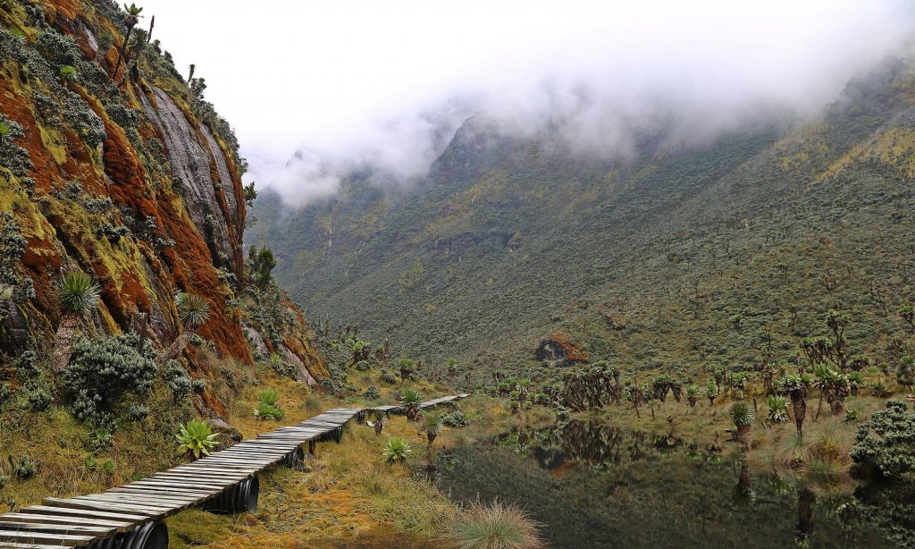
The misty, boggy, glacier-carved valleys of the high Rwenzori form a strange botanical world inhabited by triffid-sized forms of lobelia, heather and groundsel, crisp “everlasting flowers,” garishly coloured mosses and gnarled trees draped with curtains of lichen. The result is an otherworldly setting which, over the years, has been compared to the forests of the Jabberwock, the Seven Dwarves and, inevitably, Tolkein’s Middle Earth. These strange plants rank among the world’s botanical treasures, being found only on the highest mountains of East Africa.
Lakes
There are over 20 lakes in Rwenzori Mountains National Park. The lowest and most accessible is Lake Mahoma (2,651m) in the bird-rich forest of the Central Circuit. The beautiful Lake Bujuku lies at the head of the deep, glacier carved Bujuku valley in the shadow of Mounts Stanley, Baker and Speke. In the Nyamwamba Valley, ascended by the Kilembe Trail, dams created by glacial moraine have created a string of eight delightful lakes. Several rivers and streams originate from the mountain, forming lifelines for the flore and flora in the flood plains and supporting local communities.
Ruboni
Ruboni, found at the southeastern foot of the Rwenzori Mountains, is the trailhead for the seven-day Central Circuit to the high peaks. It is also the starting point for hill walks, bird and nature treks and walks through the traditional homesteads of the local Bakonzo community. Accommodation catering for a range of budgets offers gorgeous mountain views up the Mubuku valley.
Visitor Information Centre
Until the new Visitor Information Center is complete, all information regarding park activities will be available at Rwankingi Park Headquarters (close to Ruboni Community Camp), at the trailheads and the offices of the Rwenzori tour operators. Guides and porters, along with trekking equipment, can be booked by visitors at these locations.
Bulemba
Bulemba houses the remains of Rwenzururu’s first King, Isaiah Mukirania Kibanzanga, who is believed to have saved the Bakonzo tribe from the Batooro oppression. Each year on 2nd September, every Mukonzo attends the pilgrimage to this sacred site to make sacrifices.

Wildlife and Birding Summary
Wildlife
The park is home to 70 species of mammal, including six Albertine Rift endemics; four are endemic to the park and three are rare species. Other mammals include the elephant, chimpanzee, Rwenzori otter and leopard. Though wildlife is difficult to spot in the dense forest, do look out for primates such as colobus (Angola and black-and-white varieties are both present) and blue monkeys; small antelope such as bushbucks; and unusual reptiles such as the three-horned chameleon.
Vegetation
Rwenzori Mountains National Park is known for its distinctive flora rather than its fauna. On the route to the peaks, hikers climb through a series of distinct altitudinal vegetation zones; montane forest, bamboo, tree heathers and afro-alpine. The latter, with its emblematic giant forms of Senecio (groundsel) and lobelia, is one of the world’s rarest botanical communities, being limited to East African mountains above 3800m.
Birds
The park is home to 217 bird species including several Albertine Rift endemics. Among these are 17 species that are endemic to the park making Rwenzori an important birding area (IBA). The forest zone at 1800m contains a diversity of birds including the Rwenzori Turaco, Barred Long-tailed Cuckoo, Long-eared Owl, Handsome Francolin, Cinnamon-chested Bee-eater, Archers’ Robin-chat, White-starred Robin, Rwenzori Batis, Montane Sooty Boubou, Lagden’s Bush Shrike, Slender-billed Starling, Blue-headed Sunbird, Golden-winged Sunbird, Strange Weaver and several varieties of Barbets, Greenbuls, Apalises, IIladopsis, Flycatchers and Crimsonwings.
Activities in Rwenzori
Birding
Birding opportunities are greatest in the montane forest; understandably, few species choose to make their home in the inhospitable world of the high Rwenzori. Bee-eaters, Robins, Sunbirds and Barbets are some of the 217 species found in Rwenzori Mountains National Park. Other species to watch out for include the Rwenzori Turaco and Long-eared Owl; while higher up on the slopes, Bearded Vultures, Swifts and Black Eagles may be seen circling for prey.
Cultural Encounters
Walk with Bakonzo villagers through their homesteads in the foothills of the Rwenzoris as they demonstrate their daily activities, from tending to their animals and crops, to preparing meals with the freshest ingredients. See cultural dances, traditional costumes and hear their fascinating folklore.
Ruboni Community Camp – Discover the peaceful farming village of Ruboni, home to around 2,000 Bakonzo, in the foothills of the Rwenzoris. Walk with the villagers as they demonstrate their daily activities, from tending to their animals and crops to preparing meals with the freshest ingredients. Meet the blacksmith, traditional healer, basket weavers and storytellers, and enjoy a vibrant dance performance accompanied by lively drumming.
Alternatively, your guide will lead you along the rocky Mubuku River. Ruboni means clear water in the local language of Lukonzo, and you will follow this crystal-clear stream, passing villagers carrying crops and wood. As the trail winds upwards, your guide will point out many colorful native birds such as the Rwenzori Turaco, tiny sunbirds and Cinnamon-chested Bee-eaters. There are also chameleons, squirrels and vervet monkeys.
Look out for Baker and Portal Peaks rising above the forests. On a clear day the snow capped Margherita Peak is also visible – a truly spectacular sight.
Rwenzori Turaco View Camp Site – The tiny village of Mihunga faces the craggy, snow-capped peaks of Rwenzori Mountains. The Bakonzo tribe has lived here for over 300 years with no electricity or running water, and this community has adapted its way of life to the climate and steep green hillsides of the Rwenzori foothills.
Mihunga‘s community tourism group, Turaco View, takes visitors on a cultural tour of the village. This includes a demonstration by a traditional healer, whose herb-based concoctions are believed to cure many ailments. There is also a trip to the village school, a crafts demonstration and a lively dance performance.
Visitors can also choose to walk with a local guide through the surrounding forests. They may be lucky enough to spot brightly colored turacos in the forest canopy. The expert guides will be able to point out other species such as bee-eaters, sunbirds and playful black-and-white colobus monkeys.
Bulemba-Ihandiro Cultural Trail
Follow this fascinating six to seven hour trail through the holy valley and other sites of great cultural significance to the Bakonzo tribe. A community guide will introduce you to the traditional healer, explaining his powers, known as muhima; and to the local blacksmith, who will reveal the spiritual significance of the traditional Bakonzo stool. Basket weaving and fire making skills are also demonstrated along the route.
The trail then takes you across the Kamusonge River whose waters are believed to be sweet and quick to quench the thirst. There is a break in a hut to enjoy the glorious mountain views and shelter from the equatorial sun, before embarking on the final hour-long walk to the museum, thatched in the traditional Konzo style. On display are implements used during the Rwenzururu struggle, traditional dress and the other items of historical and cultural importance to the people of the Rwenzoris.
Hiking and Nature Walks
Follow the trails up to Lake Mahooma and Buraro chimp forest; through the communities of Kichamba to the Karangura ridge; and to Bundibugo area through Bwamba pass. The communities of Ruboni and Turaco View also offer guided forest walks of various lengths just outside the park
The park provides opportunity for nature walks within the central circuit zone. These include trails up to Lake Mahooma and Buraro chimp forest; walks through the communities of Kichamba to reach the Karangura ridge; and hiking to Bundibugo area through Bwamba pass.
The communities of Ruboni and Turaco View also offer guided forest walks of various lengths just outside the park. Visitors can follow the River Mubuku, and glimpse views of Baker and Portal Peaks as they hike up to 2,300m above sea level. On a clear day it is even possible to view the snow capped Margherita Peak – a truly spectacular sight. Along the way, keep an eye out for chameleons, squirrels, vervet monkeys and many birds.
Bwamba Pass: Before a road was built in 1938 to link Fort Portal with the remote town of Bundibugyo, local people followed the most direct route between these settlements – a tough, 1,500m high trek over the steep north Rwenzori ridge, known as the Bwamba Pass. The Abanya Rwenzori community group leads visitors over the mountain through isolated mountain villages to visit the bamboo forest and enjoy superb rift valley views.
Mountain Climbing
Keen climbers can choose between two scenic routes to the top of the Rwenzoris – Africa’s third highest peak! The trails pass glacial lakes, gorgeous viewpoints, dramatic mountain passes and lush valleys.
The Central Circuit Trail: This challenging, seven-day climb provides a circular tour of the high Rwenzori. From the trailhead at Mihunga, the route ascends the Bujuku Valley via Nyabitaba for acclimatization before reaching the peaks. Clients joining the Central Circuit after Bujuku will traverse the Scott Elliot and Freshfield passes to descend through the Mubuku Valley. Climbers can scale the snow peaks though many consider the exceptional scenery ample reward for their exertions.
Kilembe Trail: The recently reopened Kilembe Trail ascends the southern slopes of the Rwenzori from a trailhead at Kilembe near the town of Kasese. The route along the lovely Nyamwamba Valley passes glacial lakes and some stunning viewpoints before joining the Central Circuit at Lake Kitandara. The standard route scales Mount Baker though the scenery makes shorter treks rewarding enough.
Location: Bundibugyo, Kasese District, Uganda
Nearest city: Kasese
Elevation: 5,109m
Coordinates: 00°23′09″N 29°52′18″E
Area: 998 square Kilometres (385 sq mi)
Established: 1994
Governing body: Uganda Wildlife Authority
UNESCO World Heritage Site
Type: Natural
Criteria: vii, x
Designated: 1994 (18th session)
Reference no.: 684
State Party: Uganda
Region: Africa
